FENCEROWS... “Caves of Ice”
By John Luthens
When you reach the Apostle Islands National Lake Shore, at the tip of the Bayfield County Peninsula, it is physically impossible to get any further north on the mainland of Wisconsin. One would have to venture into the frigid and harrowing expanses of Lake Superior to do any better.
Once in the lake, maybe from one of the south lake shore villages like Port Wing, Washburn, or Bayfield, with the proper seafaring boat and the proper weather, you could island jump to any one of the 21 islands that make up the national lakeshore’s namesake. Then you could get a little further north. In fact, if you have the time and the inclination, especially in the calm and tranquil months of summer, I would highly recommend it.
The past history of fur trading, lumber camps, and shipwrecked sailors hangs heavy with the morning fogs that swirl among the islands. The scenery is stunning. And Chequamegon Bay, stretching north of Ashland and into the islands themselves, is definitely as close to a world class fishery as anywhere in Wisconsin. Smallmouth bass, lake trout, salmon and whitefish-the list goes on and the fishing is phenomenal.
Winter on the Bayfield Peninsula is really the same as summer. Well, sort of. The stunning scenery is still there, but it has been transformed to a large extent. It’s a lot colder, there is usually a lot of snow, and it often becomes impossible to tell if you are still in Wisconsin, or have somehow managed to cross into the reaches of the uncharted arctic shield.
 |
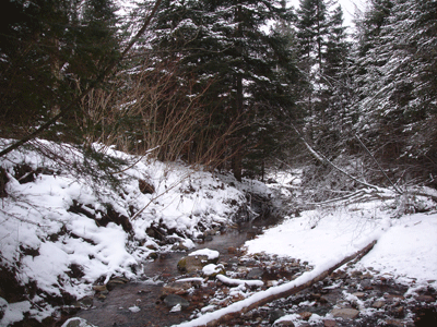
| Slippery stream crossing. |
The fish are still in the lake, but now they’re in the bays beneath twenty-some tons of ice. The ice can be a tricky proposition, but if you check with local guides, or read the local reports, the fishing can still be fantastic.
Did I mention that winters on the Bayfield Peninsula are cold and there’s a lot of snow? There are so many miles of twisted snowmobile trails, that you better have a good map and a good sense of direction. And it’s always good to keep an eye on your fuel supply, or how deep the snow actually is once you get off the beaten path. If you make a wrong turn, one of two things can happen. You get a lot of exercise hiking out, or you get a crash course in overnight winter survival-which can be quite interesting itself-but that’s another story for another day, and one I’m possibly too embarrassed to ever relate.
Anyway, there’s a lot to do in any kind of weather. When you find yourself that far north in Wisconsin, sometimes the destination itself becomes the primary goal. So with January making a push into the new year, bringing about the coldest and harshest weather into Bayfield County, I ventured into the furthest of northern Wisconsin with no intention of chasing fish beneath the cracking ice of the bays, and with no intention of becoming lost-not too lost anyway. I went with the sole purpose of viewing the ice caves of Lake Superior.
 |
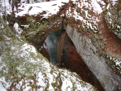
| An icy drop. |
Countless years of waves, countless winters and springs of freezing and thawing have eroded the red sandstone shorelines, cutting pillars and caverns through the island shores, and through the western stretch of the lakeshore mainland itself.
In the coldest stretches of winter the island caves can be reached over the ice. It is a dicey proposition at best. Lake Superior doesn’t fool around, and it is best to be sure the shore ice is rock solid before trying it. There is also a trailhead stretching from a parking lot known as Meyers Beach, about five miles up the peninsula from the small harbor town of Cornucopia. The trail climbs through dense forest along the lakeshore for two miles and leads to an overhead view of the caves.
With the main lake still making ice, and with floating rafts of icebergs heaving and groaning against the shore, I opted for the mainland trail. I didn’t have a choice. Barring a January polar plunge into the rocky depths of the lake, it was the trail or nothing.
The trail itself is not for the faint of heart, but it is one of the most spectacular arctic forest adventures that you could ask for this side of Canada. It cuts through dense firs that are snow covered to the breaking point. There are icy slopes and snow footbridges spanning gullies and frozen creek beds. There is even one wide open and rocky stream, splashing ice onto the eroded rocks. The eroded ice rocks are the only path across the stream.
The winds cut from the greatest of freshwater lakes. I’ve seen snow flurries on the Superior lake shores, without a cloud in the sky, when moisture from the warmer water gravitated into the cold breeze above. Snowshoe hares crash into the brush, deer trails are the common highways to walk through the heavy snow. And while wolf hunting isn’t permitted within the national lakeshore boundaries, it is likely within howling distance of the northernmost of Wisconsin’s packs. It is a place where Jack London could have felt at ease writing “Call of the Wild.”
The trail journey itself is worth the price of admission (which, by the way, the National Park Service says should be $3.00 for parking in the Meyers Beach lot). The ice caves themselves are more than worth it.
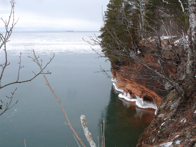
Dark chasms stretch down through snow rimmed openings. The sound of heaving ice echoes through the wind swept bluffs above the lake. Icicle stalactites hang from dark openings below the lakeshore cliffs. Out on the lake itself, white flows of ice rock back and forth with the timeless waves of the great lake.
 |
| Ice caves along Superior’s shore as a freighter rides the distant horizon. |
There is nothing between the top of the bluffs and the sheer drop of the cliffs into the lake below. Caution is a necessity on the icy slopes, depending on how close you want to crawl for a view. One false move and the whole story of these winter caves would be sunk under the shelving ice of Superior with me for eternity. I could become lost in such a place for long periods, and it would only be a fraction, an eye blink in the thousands of years of waves and winter cycles that have formed the caves.
I watched an ore freighter riding the waves far above Chequamegon Bay, far above the Apostle Islands themselves, where more than one ship has floundered and sunk. It was a cold and lonely sight, but very impressive nonetheless. I imagine that the sailors on that January ship would find ice fishing to be akin to a vacation in the balmy South Seas.
I headed back down the trail to civilization and a warm fire after cheerily waving at the ship. No one waved back. I can’t say that I blame them one bit.


